Calumet River
The Calumet River is a significant waterway system located in the Midwestern United States flowing through the states of Illinois and Indiana. Its history is closely tied to the development of industry and transportation in the region.
The Calumet River, approximately 16 miles (26 kilometers) long, starts in the south suburbs of Chicago, Illinois, and flows eastward into Indiana before emptying into Lake Michigan. It is formed by the confluence of the Grand Calumet River and the Little Calumet River in South Chicago. The river serves as a natural boundary between the states of Illinois and Indiana.
When French explorers arrived in the area in the late 17th century, they encountered Native American tribes who used a type of ceremonial pipe in their cultural and diplomatic practices. The river that runs through the region was eventually named the Calumet River from the French term "calumet" in reference to this important Native American symbol.
The Calumet River system comprises several interconnected waterways including the Calumet River, Grand Calumet River, Little Calumet River, their tributaries, and the Cal Sag Channel.

Grand Calumet River: The western branch of the Calumet River system begins in the southern suburbs of Chicago, Illinois, and flows eastward into Indiana, eventually merging with the Little Calumet River. The Grand Calumet River passes through industrial areas and has been heavily impacted by pollution from past industrial activities.
Little Calumet River: The eastern branch of the Calumet River system originates in the southern suburbs of Chicago, Illinois, and flows eastward into Indiana. It joins the Grand Calumet River in Indiana before reaching its confluence with Lake Michigan. The Little Calumet River flows through both urban and natural areas and has undergone restoration efforts to improve water quality and restore habitats.
Tributaries: The Calumet River system is fed by several smaller tributaries that contribute to its flow. These tributaries include the Indiana Harbor and Ship Canal, the Burnham Ditch, the Oxbow Slough, and various other smaller streams and drainage channels.
Cal-Sag Channel: The Cal-Sag Channel (short for "Calumet-Saganashkee Channel") is a navigation canal in the southern suburbs of Chicago. It serves as a channel between the Little Calumet River and the Chicago Sanitary and Ship Canal. It is 16 miles long and was dug over an 11-year period, from 1911 until 1922. The Cal-Sag Channel serves industrial barge traffic, as well as pleasure crafts during the recreational season.
A brief history
Native American Presence: Prior to European settlement, the Calumet River and its surrounding area were inhabited by various Native American tribes, including the Miami, Potawatomi, and Illinois tribes. These indigenous communities relied on the river for transportation, fishing, and trade.
European Exploration and Settlement: French explorers, including René-Robert Cavelier, Sieur de La Salle, were among the first Europeans to explore the region in the late 17th century. The French established fur trading posts along the river, establishing a presence in the area.
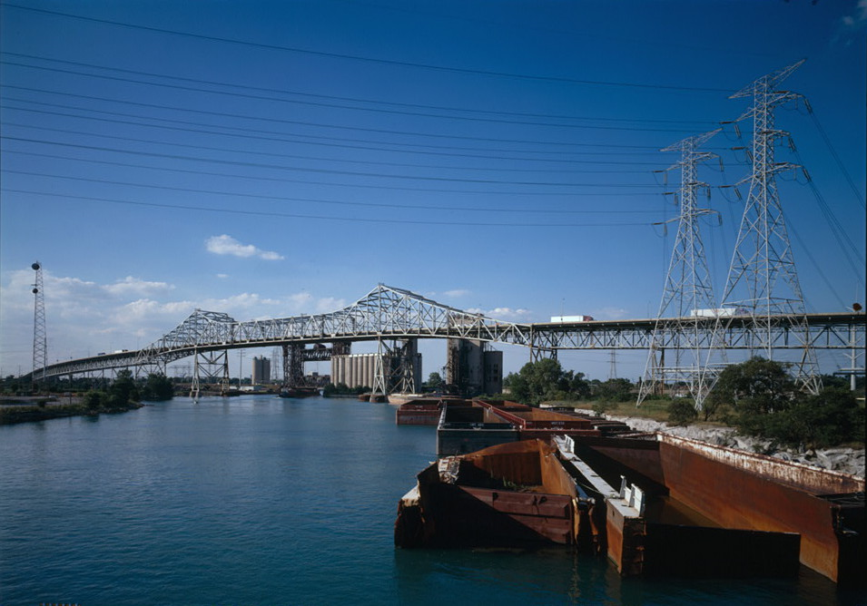
Industrialization and Growth: In the 19th century, the Calumet River became a center for industrialization due to its strategic location and abundant natural resources. The discovery of large deposits of coal, limestone, and clay in the region attracted numerous industries, including steel mills, oil refineries, and chemical plants. The river's proximity to Lake Michigan and the Chicago Canal made it an ideal transportation route for goods.
Cal-Sag Channel : Construction of the Cal-Sag Channel had a significant impact on the Calumet River. The channel, completed in 1922, connected the Calumet River System to the Chicago Sanitary and Ship Canal, reversing the flow of the Calumet RIver and diverting sewage and pollution away from Lake Michigan. This change improved water quality in the Calumet River and facilitated increased ship traffic.

 This work is licensed under a
Creative Commons Attribution-NonCommercial-NoDerivs 2.0 Generic License.
This work is licensed under a
Creative Commons Attribution-NonCommercial-NoDerivs 2.0 Generic License.
The entire Calumet River system forms a network of waterways that play a crucial role in transportation, industry, and the ecological health of the region.
Environmental challenges


Throughout the 20th century, the Calumet River has faced significant pollution and environmental challenges due to its historical industrial activities and urbanization. The river has been subjected to industrial discharges, stormwater runoff, and the accumulation of contaminated sediments. The presence of heavy metals, petroleum products, and other pollutants has led to impaired water quality and ecological degradation.
The surrounding areas have also experienced the negative effects of pollution, with brownfield sites and contaminated land posing further environmental risks. These challenges have impacted the river's ecosystem, including fish and wildlife populations, and have necessitated extensive remediation efforts to address the pollution and restore the health of the Calumet River and its surrounding environment.
Revitalization and recreation
In recent years, there have been efforts to revitalize the Calumet River and its surrounding communities. Restoration projects have focused on improving water quality, creating green spaces, and developing recreational amenities along the riverbanks. These efforts aim to enhance public access, support wildlife habitats, and promote economic development in the area.
Efforts to mitigate pollution have included the implementation of stricter environmental regulations, pollution reduction initiatives by industrial facilities, and the remediation of contaminated sites. Additionally, stormwater management strategies have been implemented to reduce urban runoff and prevent pollutants from entering the river. Habitat restoration projects have aimed to restore wetlands and natural habitats, while community engagement and education programs have sought to promote awareness and stewardship.

Recreation activities along the river include boating, fishing, wildlife viewing, and waterfront parks and trails. It's worth noting that specific recreational amenities and facilities can vary at different locations along the Calumet River. Checking with local authorities or visitor centers in the area can provide more detailed information about specific recreational options, safety guidelines, and access points.
Despite progress, ongoing efforts are needed to fully address the pollution and environmental challenges faced by the Calumet River and to achieve its revitalization goals.